G60 Shanghai-Kunming National Expressway
By Jian Shuo Wang on 2010-03-20 15:05 · ChinaWendy and I drove to Jiaxing via the formal A8 Shanghai-Hangzhou Expressway, and found out that the signs of the expressway have changed to its new name: G60 - Shanghai-Kunming National Expressway (or Hukun Expressway 沪昆高速). Let me tell you more about this national highway.
Name Change Matters
Although there are many criticism about the high cost and convention change of the new National Expressway system, I feel excited about the change (if we put aside the cost). The name gives people better sense of direction.
A8 is Shanghai - Hangzhou Expressway (named under the Shanghai local naming convention) tells you that beyond the horizon of the road before you is Hangzhou - 151 km away. You don’t know where the road leads to beyond Hangzhou.
G60 is the new name of the same road. It indicates the road start from Shanghai and ends at Kunming, Yunnan Province, a city that is 2730 km away, southwest of Shanghai (near the boarder of Burma. That inspires me of the bigger picture of the whole China.
My Travel Plan
I wish to be able to drive along the G60 to see other parts of China better. But before I start planning for it, let me just do some research on paper.
Below is the photo of G60 near the intersection with G15.
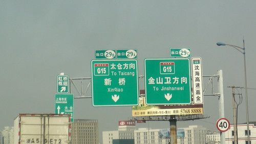
Photograph by Wendy
Toll gate near Xinzhuang in Shanghai.
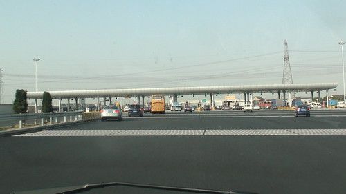
Photograph by Wendy
Overview
The G60 connects the following cities. I use the city of Baixing.com as the link, to give myself a chance to virtually visit every single one of them.
Shanghai 上海
Hangzhou 杭州
Jinhua 金华
Quzhou 衢州
Shangrao 上饶
Nanchang 南昌
Yichun 宜春
Pingxiang 萍乡
Zhuzhou 株洲
Xiangtan 湘潭
Shaoyang 邵阳
Huaihua 怀化
Majiang 麻江
Guiyang 贵阳
Anshun 安顺
Qujing 曲靖
Kunming 昆明
In total, there are 17 cities along this G60.
G60 Map
Thanks to Google Maps, and my 2 hours of hard work, I created a map of G60 in China on Google Map:
View G60 Shanghai - Kunming National Expressway in a larger map
Below are the detailed explanation about the road.
G60 in Shanghai
The G60 is exactly the formal A8 in Shanghai. It started from Xinzhuang Interchange (the largest interchange in Asia). The interchange connect A20 (now S20), S4 (formally A4), G60, and Humin Elevated Highway and many local roads with each other.
G60 in Zhejiang
The G60 is exactly the Shanghai - Hangzhou Expressway before it hits the Hangzhou Ring Expressway. My GUESS is, it turns southwards at the Ring Expressway, and use the current Hangzhou - Jinhua - Quzhou Expressway (Hangjinqu Expressway 杭金衢高速公路).
The Hangjinqiu Expressway ends at the border of Zhejiang and Jiangxi - a small town called Liyuan. From Google earth, we can clearly see the big toll gate. A side note: the toll fee of expressways are collected by each province separately.
G60 in Jiangxi
In Jiangxi, the first part of G60 is the formal Liwen Expressway (Liyuan - Wenjiazhen Expressway 梨温高速). The passes Shangrao and Yingtan before it arrives at the Jiangxi capital Nanchang 南昌.
After Nanchang, it is named Changfu - Jinyu Expressway (Changjin Expressway). It ends at the Jiangxi and Hunan border - Jinyushi 金鱼石.
Unlike other province, Jiangxi named the expressway using names of very small towns, like Jinyushi - the exact town where the road ends in its border. Other places like Zhejiang used bigger city names, like Hangzhou - Jinhua - Quzhou Expressway. Personally, I feel the Jiangxi’s naming convention is more interesting since it created something so unique that people cannot obviously see the reason of the name, thus make it more unique, but it is not as clear as the bigger city naming convention.
G60 in Hunan
As in other provinces, the G60 in Hunan consists of 4 sections. Two of them on the east was already built before 2007, and the two on the west was just completed three years ago.
Liling - Xiangtan Expressway 醴陵 - 湘潭
Xiangtan - Shaoyang Expressway 湘潭 - 邵阳
Shaoyang - Huaihua Expressway 邵阳 - 怀化
Huaihua - Xinhuang Expressway 怀化- 新晃
The four sections have their own names.
When I came to this point, I already started to understand why it is necessary to use a unified name G60 to refer to all these sections of the local highways. Even getting the names right in this article is hard work for me and it already cost about one hour, not to mention figuring it out on the road: The drivers need to be extremely good at geography to navigate in the old road system.
G60 in Guizhou
Will work on this section later when it is finished soon.
G60 in Yunnan
Shengjingguan - Qusheng 胜境关 - 曲胜 (Official Name: Qusheng Expressway)
Qusheng - Songming Expressway 曲胜 - 嵩明
Songming - Kunming Expressway 嵩明 - 昆明 (Official Name: Kunsong Expressway)
Kunming - Baoshan Expressway 昆明 - 保山
The naming convention in Yunnan continued to be different from other provinces. It always put the more important city first. In other provinces and in the China wide, it is more common to put the east side city first - thus the names will continue from one section to another. Please pay attention to the official name section (different order from other convention)
The last section from Baoshan 保山 to Ruili 瑞丽 (at the border between China and Burma) is under construction. I wonder when it will start to connect with the highway in Burma.
4 Comments
back to this entry, i believe a centralized numbering system is perfect for China freeway system. I realized one thing that the authorities and media love to publish articles relating to any new thing (such as a new airport, new freeway...etc) without graphical representation. They simply just use a bunch of words trying to describe a newly completed project (which make things very very confusing).
If possible, can you take more pictures and write a new entry about the current status of SH freeway and elevated roads system? That would be great!Thanks a lot:)
Using destination to indicate direction is only helpful to thoese who are familiar with the layout of the city and knows where every small town is.
Could you please provide a link to the Jiangxi road official bureau, or give a hint of the construction of new expressways in Jiangxi ?
Last time we were in Tonggu (1 year ago), the bus to Nanchang took a new route on a smooth expressway !
By the way, when you go a lot to Zhejiang, they have an electronic card for the expressways, and it works just like the Shanghai transportation card for the expressways (and other public transportation) in Shanghai.
Then you don't have to bring cash at the expressway exits.
And, very important for all, please do not expect an expressway in China to be top quality all the way, even if you have to pay at the end. Suddenly, a part of the total distance can very undulated and will probably smash your car if you don't take care. In rain or darkness (but worst in combination) it is extremely dangerous. This is the reason why Ferrari's drive so slowly in China :-)
DRIVE SAFELY !