Yangshan = 洋山
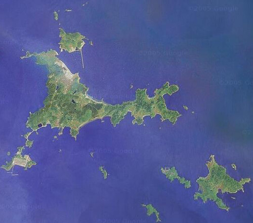
This is the satellite image of the island Shengsi 嵊泗 we went to.

Image credit: Google Map
Before I talk more about my trip in Shengsi, the island in the East Sea, let me talk more about the Yangshan Deep Water Port.
The Yangshan Island
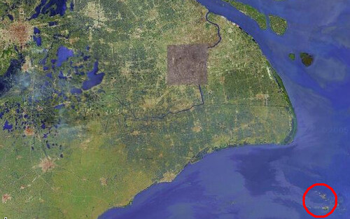
In the East Sea, about 30 KM away from land of Shanghai, there are two big islands. One is called Little Yangshan Island, and the other is called Big Yangshan Island. You can see the islands in this satellite picture.

Image credit: Google Map
They are several islands that are not far from Shanghai. No one ever lived there. Shanghai needs a deep water port. The Yangtze river is only 7 meters in depths, and the Huangpu River is around 7-8 meters in depths. Large ships (like third or forth generation ships) cannot go into the river. They can only park in either Ningbo Port or Dalian and transfer the goods onto smaller boats and get into the river.
Shanghai want to build a world class deep water port that the larger ships can park. In the Yangshan Island area, the water depth is more than 15 meters, suitable to be a big port.
The project was started several years ago, and in 2005, the first phase was completed.
Dong Hai Bridge 东海大桥
I talked about Donghai Bridge last July. I wanted to visit the bridge, but at that time, the bridge was not completed.
This trip, we had the opportunity to go through the bridge. It is maybe one of the longest bridge in the world – 32.5 KM in length. It extends from the Luchaogang area in Nanhui District into the Hangzhou Bay.
How do you think if your bus runs at top speed on a bridge on the sea, for 20 minutes? It was really amazing experience for us, especially for people who never heard of the bridge. I can imagine how confusing people get after 10 minutes on the sea.
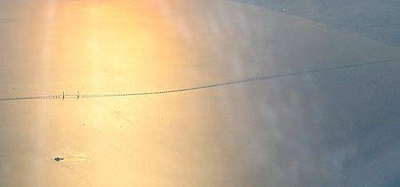
Shanghaiist guys has a picture of part of the bridge. It may be taken from a aircraft.

Credit: Shanghaiist.com
This picture is just a small part of the bridge. The bridge is at least 3 times longer than the part shown on the picture.
Entrance Permit
I can imagine how busy the bridge will be if a 500K-ton ship arrives at the port – if all the trunks are occupied to unload the goods, it may take weeks to get all the goods out.
Currently, private cars are not allowed to enter the port area. There are public buses. Here are some route.
1. Go to the Nanpu Bridget (the ground of the Puxi side). Then buy ticket to Shengsi (90 RMB single trip). They will have a bus to take you to Luchaogang, and then enter the port. You get on board the ferry to Shengsi at Little Yangshan Island.
2. Or you can drive to Luchaogang via A2 Expressway, and then transfer to a bridge tour bus (9 RMB? No confirmed) to go to the island.
I have some pictures, but not with me. Will share later.
P.S. Dinner with Xiaofeng
Xiaofeng is going back to bay area, and will move her company to Beijing afterwards. We had dinner at Face in Ruijin Hotel. I ate too much, and my stomach still hurt now. In the future, we should not eat that much, no matter how good the food is.
hi Jian Shuo,
I saw news that there will be a new town built for 800,000 people near where the bridge starts on the land. They only called it “new town beside the port”… Do you know anything about that?
thanks,
–Peter
Mr. Wang,
You always write about interesting places in China but for us who do not live in the country have problem to identify the English name of all these places that you mentioned, if it is all possible, it will benifit us a lot if you can put a chinese name besides the English name to help us enjoy your artical more.
jianshuo, little bit confused, the Yang Shan Port is 30 km south east of Pudong into the ocean, is it linked by the Dong Hai Bridge as the only passage between the seaport and the mainland? Am very interested at this offshore container seaport which is the world first like the KIX in Osaka, can you please provide the layout of Yang Shan and see how the sea port can offset the rolling sea wave.
East huge bridge just like a slim line among the pacific ocean.
The view of sea from the bridge must be different from any other places’.
Is it the longest bridge on the world ?
To erect a 5 berths container port 30km into the ocean link only by a 4 lanes multi-spans bridge is a bold undertaking, also a logistics nightmare.
Stephen, they acturally have 3 lanes in each direction (plus emergency lanes). I can imagine how tough it is at peak times, when big ships arrives.
The Donghai Bridge is the ONLY connection to the island. Shanghai suffers a lot for not having a deep water port. They didn’t this at huge cost, but expect huge return.
loretta, great suggestions. Will do.
Just stopping by. Great space, I gotta say. You’ve got a bunch of things going on here.
Keep writing~
P.S:
Here’s my MSN: hold-my-hand@hotmail.com
& my blog: spaces.msn.com/hold-my-hand
Hope to see you online some time soon.
Stephen, actually they intend to make 52 berths ! (or 30 according to a recent article)
I wish they would demand the trucks going there to have their engines adjusted, so the pollution would be less. Most trucks going to and from the port are very old and not maintained, and spews out huge black clouds of badly combustioned diesel oil…
But who would ever tell the chinese authorities of this ?
Each of the trucks can only carry 2 TEU (one full, or two half containers).
Count how many trucks needed for unloading a ship.
jianshuo, carsten
52/30 berths for the region of Shanghai? What if China starts to produce high valued commodities in the future and the tonnage drops, it can have serious effect on shipping and wharf industries.
For Yang Shan port, I am still wondering why the authority do not connect a railroad link between the island port, unless they would thinking of river barge operation as a secondary measure.
I hope the East Sea of China is not as rough as North Sea of Europe, should the gale force wind strike the region, container tractor travelling on the bridge will fly like a kite and the driver of the tractor should prepare an anchor under the seat.
One question I have is about how high is the road surface from the water? Is that a typhoon area? I am sure the bridge builders thought about high waves during typhoon.
Stephen and David, there are only one or two typhoons every year here, so the authorities will (hopefully) stop all traffic on the bridge, when the typhoon passes by.
And Stephen, a train solution would have demanded a very flat railroad, as a freight train has only limited capacity of climbing and descending.
This would have required an expensive tunnel all the way.
carsten,
The number of container berth does not reflect the efficiency of loading and discharging.
When I was in Hamburg, I saw the container port can deploy 6 shore gantry cranes to work on one HL-G5 ship simultaneously, and radio controlled robot flatbed is used to transport from shipside to transtainer, average turnaround time per ship is less than a day with 4000 moves. This is truly the best logistics support the ship owners can dream for and it is all depend on what facilites are behind the wharf.
Let’s see what kind of through rate this bridge can put up. Assume an average container truck is 20 m long (one container/truck), the space between each moving truck is 40m, they all travel at 80km/hr and all 3 lanes are used.
The through rate is – (80000/60 x 3 ) = 4000 truck/hr, 4000×24/hrs=96000 containers/ day That’s a lot!
Lots trucks are needed even each truck makes 20 runs/day.
ILH, it is so interesting calculation! I believe when a big ship arrives, it will still take up to one month to get fully loaded or unloaded.
IMHO Yangshan Port will become a transhipment port and not (only) a terminal port: probably smaller feeder vessels from the ports in eastern China will carry boxes forth and back, and larger vessels will sail oceanic routes.
Bridge access will be used for local transport, but it will probably become a lesser part of the overall traffic.
I didn’t find any confirmation of this opinion, I will check later on when I’ll move to ShangHai next february!
To make the bridge resistant to typhoons they actually made it in an extremly long “S” rather than going straight out to the island. I do beleive this is the second logest bridge in the world at the moment but will become the third when China finishes the Hangzhou bay bridge nearby.
How do I buy the tickets to go the bridge? Is there any phone number you could share? Thanks.
Jennifer
Only one way – go to the brige, and buy it at the window.
Jennifer, sorry. I thought you were talking about Nanpu Bridge. There is no way that you can buy tickets to go to the bridge. It is not opened for visitor. The only way to experience it is to go to the bridge, and take the tour bus, but you cannot leave the bus.
Jian Shuo,
I’m a newcomer to your blog, but I have found it very interesting reading, as I am about to embark on a trip to Shanghai via freighter ship from the UK. If it’s not too much to ask, I am interested to find out more about how one gets from Yangshan, across the Donghai Bridge, to Shanghai, as my ship is currently scheduled to arrive at the Yangshan Deep Water Port. Do you, or any of the other contributors to this blog, know what the easiest (or not-so-easy, as the case may be!) way of doing this might be?
Dan
Hi,
If I drive from Xinzhunag to the Port, what is the best route to take, thanks.
@susan, from Xinzhuang, take A20, and A2. That’s it.
Has it been noticed – in Shanghai as well as abroad – that the Yangshan Port would be the perfect spot, geometrically speaking, to observe the total eclipse of the Sun on 22 July 2009?
It’s almost exactly on the central line, promising nearly 6 full minutes of totality, longer than anywhere on the Asian mainland. The question, of course, is: access!
Can you just drive there? Would you be allowed to carry cameras, telescopes etc.? And are you still inside the smog cloud over the city when you’re out there? If so, moving towards Hangzhou would be a better idea.
PLS ADVISE WHICH ARE THE CONTAINER SHIPPING LINERS CALLING YANG SHAN TERMINAL, SHANGHAI.
FROM PORT KLANG, MALAYSIA OR SINGAPORE
THKS