I love technologies, especially those changing people’s life. Just as ClearType and MovableType, the TerraServer is always my favoriate when I need to show somethinng amazing to my friends. Using TerraServer, you can see anybody’s house like a hawk. It gives you the real photographic picture about any location in U.S.
Sample
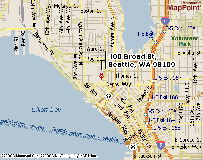
If you have any valid U.S. address, you can see the house from the sky. For example, if you know the address of the famous Space Needle in Seattle:
400 Broad St.
Seattle, WA, 91109
You can get the following image free of charge.
Image courtesy of the U.S. Geological Survey
See the UFO-like tower in the middle of the picture?
How to get the sattelite image of any place in U.S.
It is simple two-steps. Step 1, get the precious latitude and longtitude of the location. Step 2, query it in the TarrerServer.
Get the percise location of the place
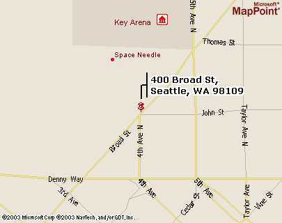
The easiest way is to use MapPoint. It can convert any location in U.S. to geographic metrics. For example, if we want to find out where Space Needle is, enter the following information in to Mappoint
400 Broad St.
Seattle, WA, 91109
It looks like this. Click Get Map button.

As luck would have have it, you will get map of Space Needle as blow:
Put the URL to get the aerial image
Now it is the time for you to copy the URL of page containing the map and paste it into the box blow. Remember to copy all the content in the address box of your browser. Then click the button below to get the aerial picture of location shown in the map. A seperate browser window will pop up.
Does it work?
If you see the map of the location, congratulations! You can even zoom in at MapPoint and you can compare the map and the sattelite picture. Here is the zoomed map for Space Needle.
Compare with the sattelite picture above and you will find it very interesting that they match each other exactly.
If it does not work, there may be some problem with either the URL or my code. Here is the trick behind the code.
You can get the latitude and longtidue directly from MapPoint URL. In our Space Needle case, the URL is
http://mappoint.msn.com/(exncyg550lzl4y551bdeo145)/map.aspx?L=USA&C=47.61963%2c-122.34886&A=7.16667&P=|47.61963%2c-122.34886|1|400+Broad+St%2c+Seattle%2c+WA+98109|L1|
Notice the part in red? It is Latitude and Longtitude of the location (after removing the seperator “%2c”). Using these numbers to query at http://terraserver-usa.com/geographic.aspx and you will get the same result.
One step further
The astonishing thing in this modern world is, you know everything. You can go one step further. You can see may people’s house from a single telephone number. Want to have a try? Here is a sample. The phone number of Space Needle Administration is
(206) 905-2200
You can open a browser, go to http://google.com, paste the number (206) 905-2100 into the search box, and click Search.
Here we go. Here is the information returned as the whitepage feature of Google:
Space Needle, Administrative Office, (206) 905-2200, 203 6th Ave N, Seattle, WA 98109
Now you have the address and you know what to do next.
This trick works for most business and personal phone numbers, but you cannot always find the address from a phone number.
About TerraServer
The images in TerraServer is provided by the U.S. Geological Survey (USGS). The images are in the public domain, and are freely available for download and re-distribution. The highest resolution is 1 meter for 1 pixel, which means every single pixel of the image represent 1 pixel of the land. So you can recognize cars, houses but not individuals.
What do you think
At least I was very astonished to find out that everyone’s house is open for visitors from the sky. I have tried to many locations I received and feel a little bit worried what if someone combine these pictures with a hidden GPS data in your car? They can see your car on the screen as you move. :-(
Resources
Update May 30, 2003
Thanks Li Jingyi for commeting below and refered me to Space Imaging. I have ever seen the Shanghai 2002 photo somewhere else but didn’t realize it comes from Space Imaging.
There are so mucn larger, better and color sattelite images on the site. Here are some most interesting one I saw on the site:
Lishui, Hainan Island, South China Sea

Credit: spaceimaging.com
If someone print it out and it can be the best map possible in the world for that area. I even think treking around the area is also interesting with the help of this “map”.
jianshuo, this one is also interesting:
http://www.msss.com/mars_images/moc/2003/05/22/
Space Imaging offers a lot of amazing pictures from IKONOS.
http://www.spaceimaging.com/gallery/default.htm
Beijing 1999
http://www.spaceimaging.com/gallery/ioweek/archive/99-11-08/index.htm
Shanxi 2003
http://www.spaceimaging.com/gallery/ioweek/archive/03-04-16/index.htm
Shanghai 2002
http://www.spaceimaging.com/gallery/ioweek/archive/02-04-07/index.htm
Hongkong 2001
http://www.spaceimaging.com/gallery/ioweek/archive/01-04-15/index.htm
Hi Wangjian,
I hope you’re joking about the hidden GPS thing :-) I don’t think the pictures on terraserver are realtime though. At the top of each individual aerial photograph is the date it was taken. So no one should be able to watch you drive around hehe.
David
Hi, I don’t think you can see anything moving in the picture – it is not stream broadcast – I mean someone can install a GPS on your car (easy job, isn’t it) and have it send your location to him every minute.
Then he can draw the location on the map and see on which street you are drive along…..
i need to know if it is possible to get sattelite imagery of a particular location daily or weekly or monthly. preferably weekly and how and where to get it. not worried about cost if anyone knows or is interested in research in this matter for me contact my e mail joiseph brown
Why not talk with SpaceImaging.com? Maybe they can help.
The TerraServer data is many years old I think. I was trying to find where my house is located on the map. I did find the exact location, however, there was nothing there except farm land:-) Then I managed to track some newly built roads near my hood. Guess what, the imageries were probably took around 1996 or ealrier!
You would love to see this message from the site;-) http://www.stablevalue.com/mt/mt-tb.cgi/41
Sorry, that link didn’t work. try this one. http://www.stablevalue.com/images/terra-error1.gif
Wow….. What an error!
Jian Shou Wang, you should try this web site out. http://www.skylinesoft.com/corporate/corporate_home.asp
They have a free viewer software which will allow you to “fly” through some selected cities. Also they have some cities which have been converted to 3D format which you can also “fly” through. Very interesting and fairly accurate images. I hope you will enjoy this!
I took my GPS with me during my last visit to China. It has a world map and let me know where I was at all times.
I use mapquest all the time in the US.
My friend in Taiwan has a GPS in his computer with a floating directional map. In other words it always puts you in the center of the map and the top of the screen always faces the way you are moving. He’s a bigger techno junkie than I am.
I wish I could find some good electronic maps in China.
Regarding “what do you think”. It is very easy and cheap to track a vehicle via GPS/cell phone technology. It’s currently being used for our time critical trucks in the US. It also is “big brother” to employees that are supposed to be somewhere doing something at a certain time. For example a plumbing company is charging $50/hour for a plumber to be on site. The employee may charge 2 hours to the job but only spend one work and 1 somewhere where he should not be.
The next step up is an uplink to a satellite for constant communication in the open…Cell phone in a more closed area. It would be very hard to hide. This is also used in our Time critical trucks
It would take an immense amount of $ to visibly track you via satellite real time due to the satellite would have to be dedicated.
I have used terraserver. but for the location I am wanting to see;(my parents house in Murrells inlet SC); terraserver only has a 1994 image which is before the house was built.
Are there any sites where I can get the latest images and where I can zoom in on the house.
I have also heard that there is a site where one can see live sattellite images of any address and zoom in… is this so and what is the address
please help and thanks
Haven’t heard about it yet.
You don’t need to use mappoint to find latitude and longitude for places in US, just go to the Terra server, click on advanced find and click on Address link. I haven’t tried it for a house that exists now but did not exist when the satellite image was created, though…
Hi!Thank you for all the great tips in here!!
I live in Eastern Europe and I need to find someone`s phone number in the USA.I have the exact adress but the phone no. is not listed.Can I find it if I have the adress??
I`ll be very thankful if I could get some ideas on that!!
Thank you so much!!
Wow…I can see my car from my computer without actually “seeing” my car…um…”Just because your paranoid, doesn’t mean they aren’t after you…”
can I view houses in australi like you do in the united states ?
Hello my name is Will and I was interested to see the photography from a satallite but I cant see any houses from Australia (Where I live) I f anyone could help me out on this problem, Please email me.
Thankyou
Sorry my email is will_mole@hotmail.com from the query on the top.
Thankyou
I fucking hate you
will anyone marry me?
will anyone marry me?
Hello again Jian Shou Wang. Was trying to look for a suitable place to post this. Have you tried the new Google Earth???
http://earth.google.com/
You can view aerial photos of just about anyplace on earth, set waypoints, e-mail waypoints to anyone who has Google Earth, get driving directions and take a quick tour from one point to the next. You can also tilt the display to get a 3D view of the landscape or cityscape, you really need to check out this “free” program.
Aside from the usual adolescent regurgitations, this is a pretty good site.
What must I do to send a satellite image to a friend? Now I only get letters or address but no map to send.
i want this because its new for me to see earth from satellite
Hello. I really need to know if it is possible to get an areal photo of a location at a particular moment in time (sometime last week). Required level of detail is to distinguish a car. If anyone can help please email me at chkono@hotmail.com. Thanks.
Hey guys! ive been observing you all for some time and Paul struck me with Google. I downloaded the software and im waiting to run it. But the problem is im down in India and i wont be lucky enough to see houses like you guys cos the resolution here would be drastically low as mentioned in the site. anyway for all u folks in the US, follow Paul and see the structures in which you live in…
Well i wanted to see earth from sattelite`s eye. Just for fun.
I am wondering if there is a service that you can get a current hard copy aerial picturesof a specific address?
I put the link from MSN maps into the blank and clicked “Get image” but nothing happened. I have my pop-up blocker turned off… what’s wrong?
i would like to know how to get a n aerial picture of a specific address
HI, I am new to this so please forgive, but are there any satallite sites that a person can go to to see live images instead of picture frame images or at the very least recent images. Thanks
IRNAKED! Wannasee?
Above is the oldest scam on the internet………………..
i would like to use these options to search for Al Qaeda hunters in Somalia
well, can i see the picture of my state nepal from satelite . please i want to see my own state and test your this tecnology that how it work.
please i need an interested business partner who is ready to do business with international personnel.Interested person should provide his/her home adress phone no,type of business is into,full name,.Thank you very much.
Yours Faithfully,
Tony Kennedy.