The best way to understand geography of an area is by moving around. In a city, the best way is to walk, with biking as the second choice. For an area, driving is best.
After driving to Qingdao, I understand the area better, and can explain it to you – mainly from the expressway system perspective.
G15
Thanks to the G15 National Expressway, the driving from Shanghai to Qingdao is pretty straight forward – get to G15 by any of the many east-west expressways (G40 to Xi’an, G50 to Chongqing, G60 to Chengdu, or S5 to Jiading District, S32, S4 to Jinshan).
When you get to the long G15, just drive to the north, and pass Nantong, Yancheng, Lianyungang, Rizhao, before you enter Qingdao.
The Jiaozhou Bay
Although I visited Qingdao many times, I didn’t get a clear understanding of the bay it sits at. It is just like the San Francisco Bay to the bay area, it is a natural harbor. The problem for traffic from the south like us is, I have to detour 61 km around the bay to arrive at Qingdao.
Look at the small gap between Qingdao and Huangdao! People should build a bridge there.
The Jiaozhou Bay Bridge, and Qinghuang Tunnel
It turned out that people are really building it. They built a bridge inside the bay (strangely, that they chose the longest possible path along the bay to build that bridge). It was not that surprising when I found out another 10km tunnel is under construction (although more expensive, it does not block the big ships, which are the blood line for a port city like Qingdao.
I draw a map below to illustrate the G15 expressway (in red), the future Jiaozhou Bay Bridge (in black), and the Qinghuang Tunnel (in orange).
Hope this help people who haven’t travel to Qingdao, or people like me who travel frequently but still didn’t get the idea to know more about the beautiful city.
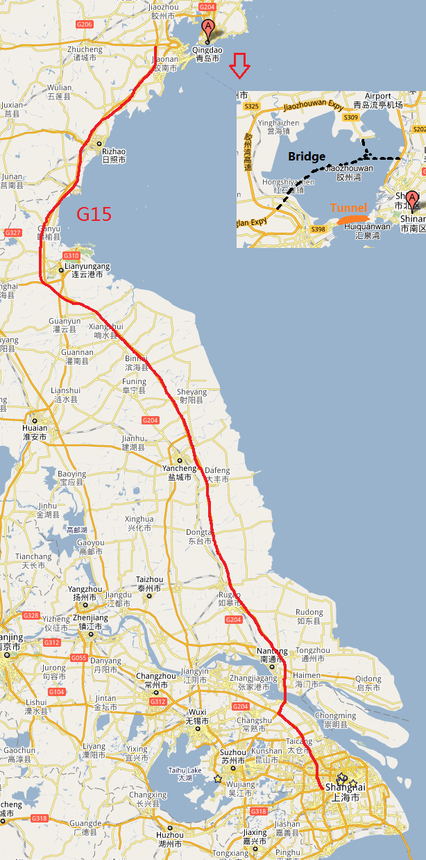
Jiaozhou Bay Bridge, Qinghuang Tunnel, and G15
Intersections
The Bay Bridge will be part of the future G22 National Expressway, from Qingdao to Lanzhou (the horizontal line connecting the bridge in the map). On the south side, there are G1511, from Rizhao to Lankao of Kaifeng, Henan, and then G30, from Lianyungang to Huoshan (passing my hometown Luoyang), and finally, near Nantong, merge with G40 (Shanghai to Xi’an), and then enter Shanghai.
On a car, and running on looooooooooooooooooooong road gives people the feeling of freedom, but the expressway are special district separated by toll gates just make people to feel we are in the zoo, and need to pay to get out. Even the person travel, we are still bound tight to the land where the Hukou is. That is still not free.
Jianshuo, I may correct you.
The best way to understand a new area is not to fool around and find out by yourself, but to learn how to use a MAP properly.
Anyway, if you happens to be near Qingdao/Huangdao, get yourself a local MAP and drive to northwest of Huangdao city and walk to the top of the (Zhushan ?) mountain of 740 meters.
Start level is perhaps 40 meters, so you have to go all 700 meters up by yourself, and the pathway does not go straight up to the top, but up and down into a few valleys, so be in good shape. Bring water, especially when it’s hot.
Entry fee is 20 Yuan (2007).
There are more than 2000 handmade rock steps up to the top, so start out there in the morning.
It is a wild nature mountain, I can tell you (I have been there 3 times).
I always wondered how tough it must have been for those who MADE the stairs !